


SityTrail GPS-Tour Trail
Beschreibung von SityTrail GPS-Tour Trail
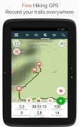
Erkunden Sie alle Pfade der Welt!
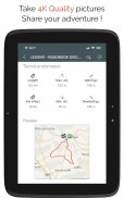
• Speichern Sie Ihre Touren und nehmen Sie mit Geo-Tags versehene HD-Fotos von Ihren Abenteuern.
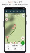
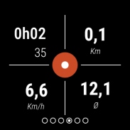
• Zurückgelegte Strecke, km-Leistung, Durchschnittsgeschwindigkeit, Tempo, Kalorienverbrauch.
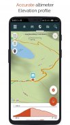
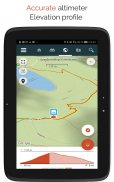
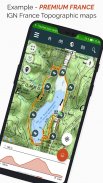
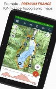
• Präziser Höhenmesser, Höhendifferenzberechnung und Höhenprofil mit Anzeige Ihrer Position.
• Alarm, wenn Sie von der Route abweichen. So verhindern Sie, dass Sie sich verfahren oder umkehren müssen.
• Automatische Ausleuchtung von POIs und Lesen von Texten mit Sprachsynthese.
• Ihre Daten überall zugänglich dank eines Server-Accounts.
• Einfache Erstellung von Routen und POIs von unserer Website aus.
• Erstellen Sie Ihre Wanderprojekte am PC/Mac mit dem Online-Editor und einem Webbrowser, und erleben Sie sie vor Ort mit Ihrem Smartphone.
• Sortieren und organisieren Sie Ihre Daten in personalisierten Listen.
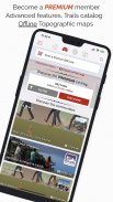
Upgrade auf SityTrail PREMIUM!
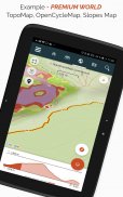
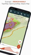
• Laden Sie topografische Karten der ganzen Welt im Offline-Modus herunter.
• Fügen Sie beliebige topografische Karten von einem Nationalen Geografischen Institut hinzu, z. B. IGN Frankreich, IGN Belgien, Spanien, swisstopo, Österreich, USA USGS topografische Kartierung, Kanada Toporama.
• Entdecken Sie alle Wandernetze wie den GR, die europäischen Wanderwege, die Wege nach Santiago de Compostela für Pilger,...
• Entdecken Sie auch alle Fahrradnetze mit Greenways in Frankreich, Ravel in Belgien, europäische Routen, die Node-Points-Netze in den Niederlanden und in Flandern,...
• Und für den Winter, alle Skipisten in Farbe mit ihrem Namen.
• Nutzen Sie den öffentlichen Katalog der Touren von SityTrail-Mitgliedern und Communities.
• Nutzen Sie die erweiterten Funktionen, um Ihre Fahrten zu verfolgen, mit geschätzter Entfernung und verbleibender Zeit sowie Sprachführung bei Richtungsänderungen.
• Gehen Sie noch einen Schritt weiter: Verwandeln Sie Ihre Lieblingswanderungen in echte Multimedia-Guides mit Text, Fotos, Links zu Videos usw. und teilen Sie sie mit der SityTrail-Community.
• Erstellen Sie Rad- und Wander-Communities und verwalten Sie Ihre Mitglieder und Newsfeeds.
• Erstellen Sie Wander- und Radtouren mit erweiterten Bearbeitungsfunktionen auf unserer Website.
• Afdrukken in PDF van A4- en A3-kaarten met QR-code.
• Konsultieren Sie Wikipedia-Artikel mit Geolokalisierung über unser SityTrip-Modul.
Wichtige Informationen
• Einige Funktionen erfordern eine Internetverbindung.
• Bei längerem Gebrauch des GPS kann sich die Lebensdauer der Batterie verringern.
SityTrail GPS-Tour Trail – Version 12.15.1.55
(17-02-2025)SityTrail GPS-Tour Trail – APK Informationen
APK Version: 12.15.1.55Paket: com.geolivesNeueste Version von SityTrail GPS-Tour Trail
Weitere Versionen


Apps in derselben Kategorie

Das könnte dir auch gefallen...


